|
|||||
|
|
|
|
|


Register in person (Registration form, waiver) | return to terraloco home
I thought, this might be the one event where I don't need to bring signs. If only I had stuck one in the window! Last year, 25 people found us inside without issue, I think, but this year, a number were wandering around the front, looking in and not seeing a crowd, and not sure we'd be in the back of the Round Table restaurant.
We had our little party going on in the back, which turned into a pizza party after enough people returned. They feasted on the fun downtown course too. Along with the route challenge of the dogbones, there were some technical alleyways to navigate as well. And, since it's too much of a risk to put out flags, the ever fun question and answer format also posed a few challenges, making the running times notably longer than for a regular course.
People came from as far as Los Angeles (on a business trip.)
Results - West Dogbones
Nick Corsano 26:36, 2.25 km, 3BA-1AB-2AB
Results - East Dogbones
Chris Buchner 3.64 km, 4A-4B-5A-5B-7B-7A-6A-6B-8B-8A
Results - Full Dogbones
by distance: (as measured on the
straight line between checkpoints)
Lyubov Solomakha 5.40 km,
2B-2A-3B-3A-1A-1B-8A-8B-6B-6A-7A-7B-5B-5A-4B-4A
Mark Day 5.51 km,
4A-4B-5A-5B-7B-7A-6A-6B-8B-8A-1B-1A-2A-2B-3B-3A
Nick and Kathy Giori 5.55 km,
3A-3B-2B-2A-1A-1B-8A-8B-6B-6A-7B-7A-5B-5A-4B-4A
Mikkel Conradi 5.57 km,
2B-2A-1B-1A-3A-3B-5A-5B-7B-7A-6A-6B-8B-8A-4B-4A
Scott Porter 5.73 km,
3A-3B-2B-2A-5A-5B-6B-6A-7B-7A-4A-4B-8B-8A-1B-1A
Tapio Karras 5.74 km, (8.01 km GPS track),
3B-3A-1A-1B-2A-2B-4A-4B-7A-7B-6A-6B-5B-5A-8A-8B
by time:
Scott Porter 43:00
Tapio Karras 58:25
Nick and Kathy Giori 58:34
Mark Day 65:20
creative interpretation of the
dogbones format:
Toby Ferguson 5.00 km, 56:36,
3A-1B-2A-2B-3B-1B-8A-8B-6B-6A-7A-7B-5B-5A-4B-4A
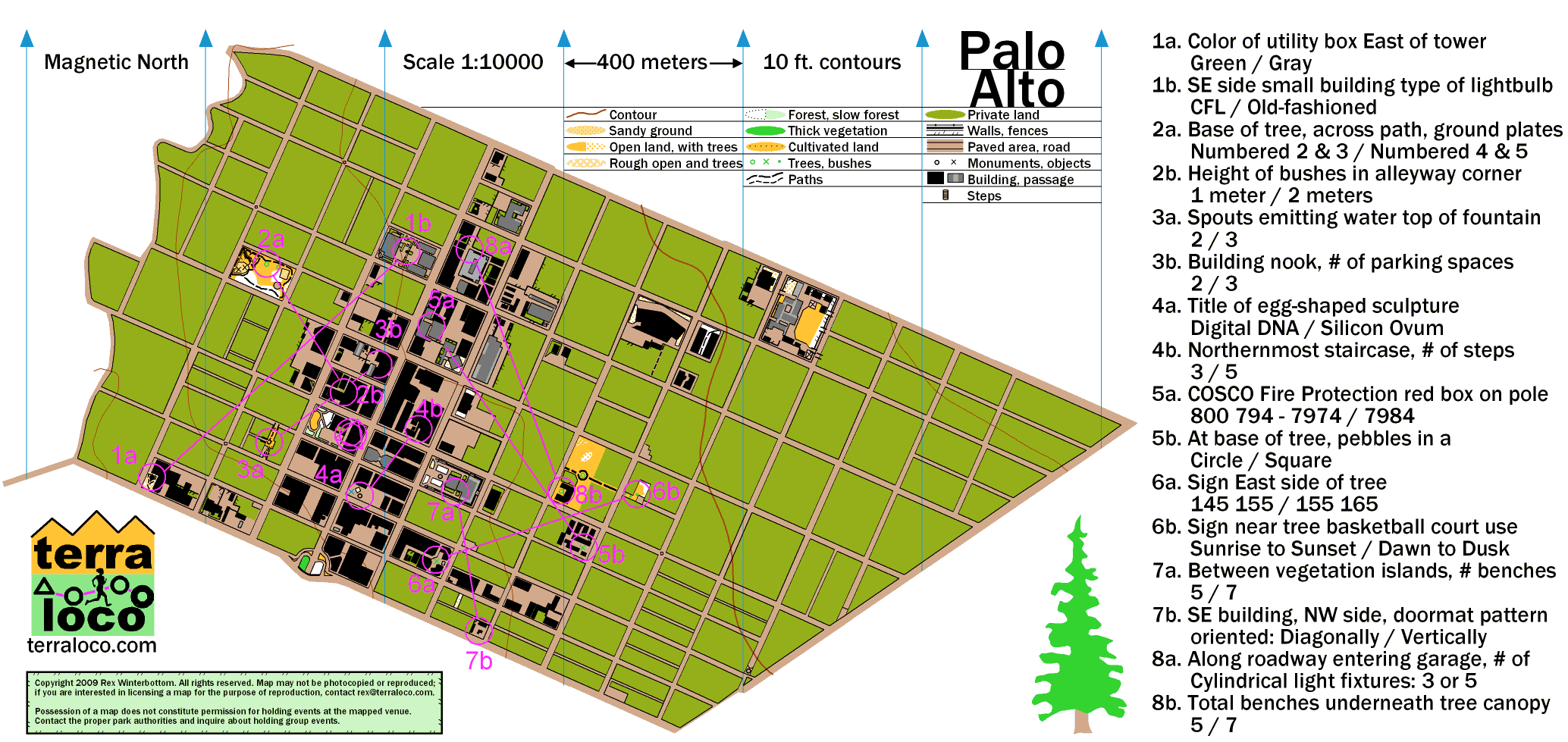
Map and Courses
Original Announcement
Downtown Palo Alto is tons of fun on the run; just remember to put safety first as wheeled vehicles are omnipresent. You'll get many opportunities to leave them to the streets and explore some interesting urban spaces and parks. We'll meet at the Round Table again where we can party afterwards.
What's the Deal?
Yes, it's another pile of Dogbones! It's the best way I can think of to add challenge to a relatively non-technical area. Better than "Score-O!" And it's a challenge that's good for all levels of nav. experience here. You can take the checkpoints in any order, but you have to take them a pair at a time; pairs are shown by connection lines on the map. (Hence, "dogbones.")
Full Dogbones: 18 checkpoints
(9 pairs), shortest point to point distance I could
calculate is 6.6 km, minimal climb, crosses
University Ave. twice.
Dogbones East: 12 checkpoints (6 pairs), shortest
point to point distance I could calculate is 4.4 km,
minimal climb, crosses University Ave. twice.
Dogbones West: 6 checkpoints (3 pairs), shortest
point to point distance I could calculate is 2.3 km,
minimal climb, never crosses University
Ave.
Although there are no major thoroughfares you must cross to do the course (aside from University Ave., if you count that,) traffic is a serious consideration out there. Avoid reading the map while crossing the street, and always look! Major thoroughfares are the boundaries of the map - Alma St., Embarcadero Rd., and Middlefield Rd. - so if you reach them, don't cross, because you'll go off the map and there are no checkpoints. And this is really just for fun - don't sacrifice your safety for a few extra seconds. You might factor in potential traffic in your route planning.
Details:
- Cost is $5 per person.
- Registration and starts open at 6:00, mass start option is 6:45, courses close 8:00, or earlier, if people are finished.
- Gear: shorts and regular running shoes are fine.
- Checkpoints are multiple choice Question and Answer - with only two answers to make it quick!
- Map from terraloco is 1:10000 scale and not very hilly.
- Social option afterwards inside Round Table.
Directions:
From U.S. Highway 101 in Palo Alto, take the University Ave. exit west to downtown Palo Alto. Round Table Pizza is located at 263 University Ave. It's between Bryant and Ramona Streets.
Public Transit:
The Caltrain itself and many VTA and SamTrans buses can take you to the Palo Alto Transit Center. From there, head a few blocks east on University Ave. to Round Table Pizza, 263 University Ave.
Event Contact: Rex, 5 1 0 - 6 8 1 - 6 1 8 1, rex@terraloco.com