|
|||||
|
|
|
|
|

Register in person (Registration form, waiver) | return to terraloco home
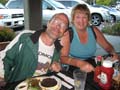
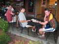
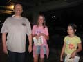
Not too hot, and the courses were interesting. Amazingly, all the flags remained, none were lifted by curious passers-by. And all that darned construction... keeps popping up everywhere. Fencing off this, fencing off that. Still, it would not deter our intrepid adventurers of all ages from completing their courses. Turnout was the best of the summer evening sessions, 28 people, eight of them juniors.
Participants did actually practice bearings and directions with the spokes course - measured 3.5 km on paper, and thanks to the runnability in any direction with hardly any obstacles (save a few roads with traffic you had to cross) it measured only 3.67 km in actual distance, according to Tapio's GPS logger. He did the course in 19:01. Alex Finch did 20:47 but a shorter 3.62 km.
The sprint was designed to have some interesting traps, because of all the construction though, I had to make many day-of modifications to the course. So it wasn't what I had hoped or planned for, but people still managed to find challenge in it; it definitely required detailed map reading. 3.5 km on paper, it took Tapio 3.89 km of actual distance to cover, and his posted time was 20:21. Alex Finch followed in 23:44 for 4.13 km.
Original Announcement
What's the Deal?
This campus is one of the richest maps in BAOC's repertoire - features galore! And recent updates by Eric Bone.
There will be a mix of training exercises for your enjoyment; Hobee's will be our home base, then you'll cross El Camino Real to get to campus to self-start and finish your activities before crossing back over.
There will be a longer "tour" course of up to 6 km which can be shortened if you cut off the loop somewhere.
For the more ambitious,
the checkpoints will be broken up into two exercises:
1. The "spoke - and wheel course" - longer legs across the arboretum
which all cross each other - good for practicing bearings.
2 .The "campus" course - uses the obstacles and tricks in the detailed
sections of the map to give you some quick-decision-making and
route-planning fun.
Details:
- Cost is $5 per person.
- Registration and starts open at 6:00, courses close 8:00, or earlier, if people are finished.
- Gear: shorts and regular running shoes are fine, but you may encounter some high grass and some slightly brushy vegetation.
- Checkpoints will be a mix of small flags and question and answer.
- Map from BAOC is 1:7500 scale and not very hilly.
- Social option afterwards at Hobee's.
Directions:
We'll meet just outside the Hobee's Restaurant at Town and Country Village shopping center in Palo Alto.
From U.S. Highway 101 in Palo Alto, take the Embarcadero Road exit and go west towards Stanford University. At the major intersection with El Camino Real, turn right, then make an immediate right into Town and Country Village shopping center. Turn right and go along the edge of the building until you can make a left, then you should see Hobee's on your left.
Public Transit:
The Caltrain and many VTA and SamTrans buses can take you to the Palo Alto Transit Center, which is at El Camino Real and University. The VTA 22 line and 522 lines, for example, terminate at the transit center, and they stop on El Camino Real at the corner with Embarcadero.
Event Contact: Rex, 5 1 0 - 6 8 1 - 6 1 8 1, rex@terraloco.com