Urban Wild Weekend |
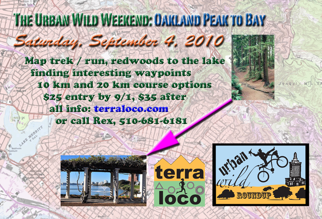
Oakland Peak to Bay: Saturday, September 4, 2010Saturday! |
||||||||||||||||
|
|
return to terraloco home
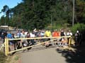
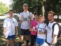
The yellow school bus picked us all up on a foggy morning. As we ascended into the redwoody hills above Oakland, we witnessed the battle between sun and fog play out. The forest glimmered with light, but it was also full of fog. Kind of half empty and half full. It's not often I've seen it like that, and I'm there a lot in Joaquin Miller Park. Although both the 10 km and 20 km courses were mostly downhill, they were quite physically taxing, and the navigation was challenging too. I didn't try to make it hard, placing all checkpoints near trails, but Joaquin Miller and Roberts can be confusing if you get off track or lost. Still, people found a way. Good thing Jonas was serving up treats at the aid station. A nice, sunny finish was had in Lakeside Park on Lake Merritt. Steve Gregg led the pack on the 10 km, and Bruce Wolfe did so with the 20 km. Both would qualify as masters, but won the respective open divisions. The Whidbey Island Nerds from the Seattle area posted a strong showing as a mixed couple, notching 2nd place overall on the 20 km course. We had some orienteers, some adventure racers, some couples, a family, and participants from their teens into their sixties. A nice mix. Good to have everybody out! Especially those giving it a go for the first time, congratulations on finishing! A special thanks to Jonas Kjall for helping with the aid station and gathering the checkpoint markers and streamers. Results - Overall 10 km 1. Steve Gregg 74:25 Unofficial - lost passport 20 km 1. Bruce Wolfe 145:22 Something between 10 km and 20 km The Bears - Ann Cottrell Results - Categorized 10 km Family 1. SR Kims - Susan Kim & Daniel Kim 214:48 10 km Masters Women 1. Adventure Turtle - Nancy Lindeman 267:55 10 km Masters Mixed 1. Team Effe Emme - John & Ariel McKnight 267:55 10 km Open Women 1. 7 Questions Tour - Lori Lewis, Ilya
Pratt 141:00 10 km Open Men 1. Steve Gregg 74:25 Unofficial - lost passport 10 km Open Mixed 1. Tohu Bohu - Wesley Willett, Lora
Oehlberg 114:26 20 km Masters Men 1. One Big Guy - Geoffrey Sears
214:13 20 km Open Women 1. Penny DeMoss 192:13 20 km Open Men 1. Bruce Wolfe 145:22 20 km Open Mixed 1. Whidby Island Nerds - Bill & Heidi Cusworth 182:45 Event Update - posted September 1 Helpful tips for participating in the event - remember to review all the original notes carefully as well. Course statistics should be slightly
longer than the "crow flies" distance on the
ground: 1. Traffic is a significant hazard
towards the end of the course; there are busy major streets
to cross. Be very vigilant and careful, and try to avoid
routes that would cross major thoroughfares, or adopt the
strategy of running along them until you hit a red light and
it's safe to cross. Also, towards the beginning, you'll
cross Skyline Blvd., which has curves, and a speed limit of
35 M.P.H. Original Announcement The Urban Wild Weekend begins with a long time dream of mine: start a course in the majestic redwood groves off of Oakland's Skyline Blvd., then tumble the participants down through the canyons and curvy streets and charming neighborhoods of the Oakland Hills and Piedmont. You'll finish on the beautiful shores of Lake Merritt. Along the way, you'll experience some of the best highlights of all these places. The courses will feature interesting legs between the checkpoints. You'll find your way with two BAOC maps (Joaquin Miller and the Oakland / Piedmont Streets) and one terraloco map (Lakeside Park.) I've chartered a large school bus to take us from the finish place of Lakeside Park to the starting point, which is near Chabot Space and Science Center. There will be two courses: a more direct course of about 10 km and a more meandering course of about 20 km (with more climb) that takes in more spectacles. Both courses are packed with adventure! Despite the Urban WIld Roundup logo having a bike, these courses are trek only. Stay tuned for an event update with more information about the courses... Event Schedule: 8:30 Registration open, Lakeside
Park So how does this work? Please be registered by 9:10 so we can board the bus on time. We will leave nothing in Lakeside Park - no one will be there "guarding the stuff" - so leave most of your stuff hidden in your car's trunk. You can throw a jacket or pants in a bag at the remote start, and you're also allowed to leave stuff like car keys if they're put in a sealed "lunch bag" type thing clearly labeled with your full name. All items will be transported back to the finish area. Just before the mass start there will be a course briefing with information that will be helpful to you in completing the course. You'll receive an event "passport" for marking checkpoints. Then maps will be handed out and you get to turn them over and look at them when the start is called. For the first section of both courses, you can get the checkpoints in any order, then you must go to the aid station at the edge of Joaquin Miller Park to get your next maps. Then you can continue to get the next set of checkpoints in any order as you work your way to the finish in Lakeside Park. At checkpoints, you will answer a multiple choice question about a recognizable map feature, or you will find an orange and white marker and use its dangling puncher to mark a punch pattern on your event passport. To place in the event, you need to correctly mark all checkpoints on your passport. What will I need?
Optional gear:
Hazards
What happens when we're done? There's always lots to talk about and people to visit! Hang around and enjoy complimentary refreshments and snacks. We'll tabulate and post results as soon as we can process them. There will be award certificates for the top three teams / individuals in "open" and "masters" (average age over 40) categories. Cost and Registration: When you signup online, you are not committing to show up or pay. Online signups help us prepare for the event. We'd rather be overprepared, and we encourage you to sign up ahead of time if you have any interest in attending. Payment cannot be collected in Oakland parks; you will receive an email invoice if you show up to the event and participate, which you can pay after the event by credit card or by mailing a check. Or if you're attending both events, you can pay for both at Golden Gate Park on Sunday, cash or check only. Directions: We'll meet at the circular marble fountain in the forest by the eastern bocce ball court of Lakeside Park. A walking route to the fountain will be signed and streamered from the parkside corner of Grand Ave. and Perkins St. Take Interstate 580 to Oakland. From Interstate 580 going east, exit at Grand Ave. Turn right, and drive about 0.4 miles to Perkins St. and find parking. From Interstate 580 going west, exit at Grand Ave. This exit loops around, so you actually turn right on Grand Ave. Drive about 0.5 miles to Perkins St. and find parking. Registration will be signed from the corner of Grand Ave. and Perkins St. However, if you enter Lakeside Park at Bellevue Ave., you may be charged a $5 parking fee if the fee station is staffed. There's also street parking in the neighborhoods along Grand. Meters are active on Saturday. Public Transit: AC Transit bus lines NL and 12 stop on Grand near Perkins. Line 57 stops at Grand and MacArthur if you're willing to walk 0.4 miles. If you take BART to 19th St. Oakland, you can catch the NL, or catch the 57 from MacArthur BART. Or to walk or bike from 19th St. BART, head up Broadway to Grand Ave. (near where 24th St. would be), turn right on Grand, and go about 1/2 mile to Perkins. bart.gov, actransit.org or try the 511 transit planner at 511.org Event Contact: Rex, 5 1 0 - 6 8 1 - 6 1 8 1, rex@terraloco.com |
 Sunday!