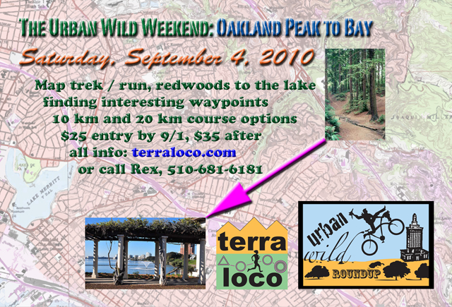
Urban Wild Weekend |
S.F. Strays to Breakers: Sunday, September 5, 2010Saturday! |
||||||||||||||||
|
|
return to terraloco home
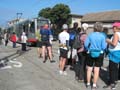
More perfect weather for a jaunt through San Francisco, I could not imagine. One of the important decisions of the day, especially for the 20 km course, was where to get off the N Judah streetcar - most seemed to around the Civic Center stop. Finishing back through Golden Gate Park, I don't know if you could have seen the sweet sights of the park in a better light. All participants got to wash the course down with some ocean water at the end - a few even managed to "keep the foam alive" in their plastic cups. Overall on the 20 km course, there was a fairly close battle between world-class orienteer Eric Bone and world-class adventure racer Rick Baraff for the top two spots, up to about checkpoint 11 in Golden Gate Park. We had three intrepid family teams of four - two parents, two children each - on the 10 km course. One visitor from Pittsburgh, and three others from Washington (in addition to Eric Bone.) The Pamakids entered a team of four, and Karen Andrews represented the Lake Merritt Joggers and Striders. A good number came from BAOC, and we had a few more advenutre racers. A special congratulations to those that did two days of courses! Heidi and Bill Cusworth (all the way from Washington,) Jason Reed, Greg Favor, Steve Gregg, Jennifer Kerr, Nancy Lindeman, and Geoffrey Sears. A big thank you to the support crew: Judy Koehler, who manned the event from start to finish, providing registration support, setup help, and anything and everything she could think of doing; Jen Klafin, who took charge of the aid station; and George Minarik, who helped with photography and setup and the aid station. For the results, keep in mind that the S.F. course times involved a train ride of up to 40 minutes!! Two-day Overall Results!! 20 km each day 1. Team Reed: Jason Reed 399:40
(186:44 + 212:56) 10 km each day 1. Jennifer Kerr 376:46 (166:01 +
210:45) Results - Overall 10 km 1. Team Buhr - Martin Buhr 116:49 20 km 1. Street Scramble - Eric Bone
179:17 Somewhere between 10 km and 20 km Results - Categorized 10 km Family 1. Jansson - Mats, Teresa, Annika,
Emma 155:10 10 km Masters Women 1. Adventure Turtle - Nancy Lindeman - 233:10 10 km Open Women 1. Ducks in Distress - Terry Farrah
186:30 10 km Open Men 1. Team Buhr - Martin Buhr 116:49 10 km Open Mixed 1. Team Monkey! - Jason
O'Connell, Ann Wang 133:00 20 km Masters Men 1. Deron Van Hoff - 214:51 20 km Open Men 1. Street Scramble - Eric Bone
179:17 20 km Open Mixed 1. A2J2 - Anna
Kurtz, John Gieng, Andy Chan, Jeff Huizinga 204:43 Event Update - posted September 1 Helpful tips for participating in the event - remember to review all the original notes carefully as well. Course statistics should be slightly
longer than the "crow flies" distance on the
ground: 1. Directions to the registration /
finish area have been slightly updated. Coming by car or
otherwise, enter the park from 45th Ave. and Lincoln to get
to the 45th Ave. Playground. Original Announcement It's the finale of the Urban Wild Weekend! We'll gather at the far west end of Golden Gate Park. Then, we'll be whisked away eastward on the N-Judah Muni train. Maps will be distributed on the train - you'll get a 1:15000 map of San Francisco streets on one side, and BAOC's map of Golden Gate Park atop the S.F. streets on the other. You decide where to get off the train - the Muni stops will be marked on the map. Which stop will work best for you? That depends on what you think is the optimal tour to get all the checkpoints. After you've returned through Golden Gate Park, the last checkpoint will be on the beach... and then you will finish back at the picnic site. There will be two courses: a more direct course of about 10 km and a more meandering course of about 20 km that takes in more spectacles. Both courses are packed with adventure! Despite the Urban WIld Roundup logo having a bike, these courses are trek only. Stay tuned for an event update with more information about the courses... Event Schedule: 9:00 Registration open, picnic site,
45th Ave. playground (near Lincoln Ave.,) west end of Golden
Gate Park So how does this work? Please be registered by 9:25 so we can depart on time. You can leave non-valuable items at the registration / finish area, which will be monitored by event staff. You're also allowed to leave stuff like car keys if they're put in a sealed "lunch bag" type thing clearly labeled with your full name. Just before leaving there will be a course briefing with information that will be helpful to you in completing the course. You'll receive an event "passport" for marking checkpoints. Then maps will be handed out. For the first section of both courses, you can get the checkpoints in any order, then you must go to the aid station at the edge of Golden Gate Park to get your next maps. Then you can continue to get the next set of checkpoints in any order as you work your way to the finish. At checkpoints, you will answer a multiple choice question about a recognizable map feature, or you will find an orange and white marker and use its dangling puncher to mark a punch pattern on your event passport. To place in the event, you need to correctly mark all checkpoints on your passport. What will I need?
Optional gear:
Hazards
What happens when we're done? There's always lots to talk about and people to visit! Hang around and enjoy complimentary refreshments and snacks. We'll tabulate and post results as soon as we can process them. There will be award certificates for the top three teams / individuals in "open" and "masters" (average age over 40) categories. Cost and Registration: When you signup online, you are not committing to show up or pay. Online signups help us prepare for the event. We'd rather be overprepared, and we encourage you to sign up ahead of time if you have any interest in attending. Directions: We'll meet at the 45th Ave. Playground. From Northbound Highway 101: Take the 101 North/Golden Gate Bridge exit in San Francisco, which becomes Octavia St at Market St. Stay on Octavia for a few blocks, and turn left onto Fell St. Follow Fell St west for 1.5 miles into Golden Gate Park. After it enters the park, the road will curve left, then curve right, and then you'll be on Lincoln Ave., which follows the southern edge of the park west to the ocean. Go almost all the way to the ocean, making a left turn at 45th Ave., and find parking close by. Walk from 45th Ave. across Lincoln into Golden Gate Park and you'll find the playground. Public Transit: 8:00, 8:08, 8:17, and 8:27 are the times the N-Judah train leaves Embarcadero Station and heads west towards the ocean. According to the schedule, they arrive at 8:36, 8:44, 8:53, and 9:03, respectively. It's about a 5 minute walk from the 43rd Ave. Stop, if you miss this, get off at 46th Ave. Walk to 45th Ave., and then head north towards the park. Careful crossing the busy Lincoln Ave.! There's a path going into the playground from that intersection. bart.gov, get SF Muni info at 511.org Event Contact: Rex, 5 1 0 - 6 8 1 - 6 1 8 1, rex@terraloco.com |
 Sunday!